UK taxes included where applicable. Export prices are excluding VAT.
Shipping calculated at checkout.
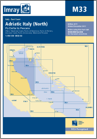
The Imray M33 Adriatic Italy – North nautical chart provides reliable coverage of the northern Italian Adriatic coast, from Ravenna to Pescara. Designed for skippers requiring accurate harbour and approach detail.
Coverage: Northern Adriatic Italian coast including Ravenna, Rimini, Fano, Ancona, San Benedetto del Tronto and Pescara
Detailed plans: Multiple harbour plans from 1:7 500 to 1:50 000 for precise pilotage
Updates: 2015 edition with revised depths and latest harbour developments for safe navigation
Format: Waterproof 640 x 900 mm sheet, folded in a protective plastic wallet for durability onboard
Georeferencing: WGS84-compatible plan of Pescara for accurate GPS use