Imray
SKU:YOT0925P
Regular price
£23.95 GBP
Regular price
Sale price
£23.95 GBP
UK taxes included where applicable. Export prices are excluding VAT.
Shipping calculated at checkout.
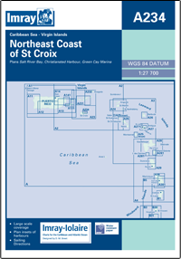
Imray A234 North Coast of St. Croix provides focused coverage of the NE coast of St Croix, Virgin Islands, for precise coastal navigation.
- Area covered: Salt River Bay to East Point, scale 1:27,700 for detailed pilotage
- Larger scale plans: Salt River Bay, Christiansted Harbour and Green Cay Marina for close-in manoeuvring
- Clear presentation: Professional Imray cartography with soundings and key navigation details
- Practical format: Flat chart supplied on water-resistant paper for durability onboard
- Ideal use: Passage planning and harbour approaches for yachts and small craft
A robust, accurate nautical chart for cruisers exploring the north and east coasts of St Croix.
Share
View full details