UK taxes included where applicable. Export prices are excluding VAT.
Shipping calculated at checkout.
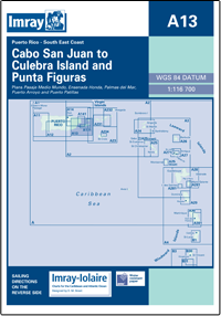
Cover the busy southeast coast of Puerto Rico with the Imray A13 chart, from Cabo San Juan to Culebra Island and Punta Figuras. Suited to coastal cruisers needing clear overviews plus detailed local plans.
Wide coastal coverage: Cabo San Juan to Culebra Island and Punta Figuras at 1:116 700
Detailed insets: Larger‑scale plans of Palmas del Mar, Puerto Arroyo, Puerto Patillas, Ensenada Honda and Pasaje Medio Mundo
Versatile use: Supports route planning, coastal transits and port approaches on a single sheet
Rugged format: Flat chart on water‑resistant paper for long‑term cockpit use
An essential planning and pilotage chart for southeast Puerto Rico passages.